No road in or out
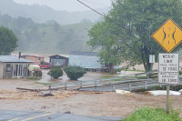
On Friday night, a mudslide thundered across Rich Cove Road in Maggie Valley, taking out a section of a guardrail and bending a drainage pipe in its path, causing water to flow alongside the road and collect at the bottom.
The landslide deposited a significant amount of mud at two spots on the road and downed several trees across other parts.
The North Carolina Department of Transportation’s chief priority will be to restore a “primitive road condition” to allow temporary access for residents and repair efforts, according to Joel Setzer, who heads the regional DOT division. But the DOT isn’t prepared to begin work right away.
“We’ll have to wait for some drier weather before we make an effort,” said Setzer. “Full restoration of the road will have to be done later on.”
According to Setzer, the DOT faces a Catch-22 when it comes to the water that’s been diverted by the mudslide. If left alone, the water will continue flowing out of its established path and damage the road and some houses, but if it’s redirected to its usual flow pattern, it will “add water to an already saturated, muddy mess,” said Setzer.
While the DOT normally reflows the water to its established path, it faces a quandary with the latest mudslide.
“We’re looking for direction on what is the best thing to do and the overall public good,” said Setzer. “It’s a tough situation, but it’s going to require some aggressive emergency management.”
After scare of slide wears off, residents want answers
Betty Miner was standing in her kitchen getting ready to fix supper last Friday when the pictures on her walls fell to the ground.
“I heard a sound and ran to where I heard it and that’s when the mud came up and splattered the window,” said Miner. “I thought an airplane had crashed right next to us or on top of the house.”
A 30-foot-high wave of mud and rock screamed by at 30 miles per hour, picking up any debris that lay in its half-mile path down the mountainside. While only four homes were damaged and no one was injured, Miner and her neighbors in Maggie Valley’s Rich Cove area were forced to evacuate after dark.
Teenager Shane Bryan was in his house watching TV when the slide hit.
“We grabbed the first things we saw and then they came to get us in the four-wheelers,” Bryan said.
The slide occurred around 6:30 p.m. on Friday, Feb. 5. Emergency responders were on-hand in less than a half hour beginning the work of evacuating residents from the path of danger.
Tammy Jones was trapped on the second story of her house after her ground floor was buried by debris.
“I heard it coming and knew what it was, but I didn’t have time to do anything but stand still,” Jones said.
Jones and her four dogs were eventually freed by rescue workers who dug their way in to a door on the ground floor to get her out and take her and the dogs down the mountain.
Cam Sutton said the slide sounded like “thunder coming down the mountain” and Tammy Rich described walking through mud up to her waist to check on her family members.
It was a night that none of them will ever forget.
Lingering threat
In the hours after the slide, the Haywood County office of the American Red Cross set up an emergency shelter at the Maggie Valley Methodist Church where eight residents from the landslide area slept Friday night. Others stayed with family or at hotels.
Ultimately, the area endangered by the slide included 13 homes lived in year-round, and another 24 that are second-homes and were unoccupied.
According to residents, on Saturday emergency management staff and staff from the North Carolina Geological Survey told them a retaining wall at Ghost Town gave way higher up the mountain and was likely the cause, but that they would continue to flesh out the details.
Church volunteers and area businesses helped sustain the displaced residents by furnishing meals. By Sunday, the shelter had closed and everyone had found housing elsewhere, but emergency management officials informed residents that anyone past the 600 block of Rich Cove Road should not return to their houses because the land above them was still unstable, posing the risk of a second, possibly even larger slide yet to come.
Betty Miner explained what she felt after the event.
“I’m just shocked that this could have happened,” Miner said. “Last night I finally slept. It’s a shock to the system and kind of a feeling of loss.”
Residents were briefed again Sunday night by emergency management personnel who had conducted a fly-over of the area accompanied by Rick Wooten, geologist from the North Carolina Geological Survey.
After reviewing the site from the area, Wooten estimated that 12,000 to 16,000 tons of material was still unstable at the top of the slide. With the weather report predicting four inches of snow on Wednesday this week, the area still presented a threat.
Some residents below the 600 block of Rich Cove Rd. chose not to leave their homes. Tammy Rich, who lives at the Sutton family home, wanted to stay on the mountain.
Rich said she and her relatives were aware of the danger the slide presented because they’ve lived with it for years.
“They told us stuff we already knew,” said Rich. “We knew there were problems with the retaining walls, because it’s happened three times before.”
The Cause?
On Monday, officials gathered the residents one more time at the Methodist Church to brief them on the situation. The shock and relief they had felt in the days following the event had begun to give way to a pressing need for clarity.
“The information stream has really slowed down,” Jones said. “We don’t know any more now than we did on Saturday.”
Cam Sutton, whose house was cut off by the slide had a simple question for Wooten.
“The cause?” Sutton said. “Do we know the cause?”
Wooten said determining the exact cause of the slide would take time. There were many factors, he said. Missing from his presentation this time around was any direct reference to Ghost Town’s retaining wall, however.
“This is an area that’s failed before. Twice at least and probably more than that,” Wooten told the crowd.
Using contour maps of the area showing the path of the slide, he explained the risks presented by the material still hanging from the top of the mountain.
But the residents gathered wanted concrete answers to practical questions. When will we know for sure what happened? When can we go home?
For Tammy Jones and Kurt Biedler, there is no going home. The foundation of their house was breached and their water system went down the mountain.
“I have no patience left,” Biedler said. “We’re 72 hours into an emergency situation and our house is not livable. The lack of information is unacceptable.”
Jones and others wondered why the owner of Ghost Town in Sky Amusement Park hadn’t shared any information with residents about what had happened.
“If it was my retaining wall and it fell on my neighbor, my insurance adjuster would be down there immediately interviewing the neighbors,” Jones said.
Jones and Biedler bought their house in May after moving from Savannah.
Jones said she has given up on returning to her house in the near future.
“I’m not interested in living below that,” Jones said. “It’s like a ticking time bomb.”
Cam Sutton, a lifelong resident who had to walk through the woods carrying his children during the Friday evacuation, was furious that Ghost Town’s owners have not met with residents yet.
“Ghost Town hasn’t been to one meeting. The community helped each other and stuck together, but the cause of this hasn’t shown up yet,” Sutton said.
Ghost Town’s CEO and a hired engineer have been involved in meetings with the county and state geologists.
“First and foremost we are very thankful and grateful no one was hurt,” Ghost Town CEO Steve Shiver said in a phone interview.
Sutton said he wants Ghost Town to make right the situation he believes it has caused.
“I would expect them to clean up the whole mess,” Sutton said.
Kim Czaja, executive director of the Haywood County Red Cross, told residents gathered at the church her staff would begin case management with people displaced by the slide on Tuesday morning.
“This is a long-term effort but right now our priority is your immediate concerns,” Czaja.
Czaja said she her staff would focus on assessing what displaced residents need and then would work to identify what resources may be available to them.
Tammy Rich spoke for the rest of the Suttons on Rich Cove Road.
“We’re just gonna ride out the storm,” said Rich. “What can you do?”
Messy lawsuits likely left in landslide’s wake
It could take months or even years for lawsuits over a massive landslide in Maggie Valley to be resolved, leaving affected property owners in limbo over who is financially responsible for the damage to their homes.
The landslide originated from Ghost Town in the Sky, a mountain top amusement park, where a giant system of terraced retaining walls gave way. N.C. Geologist Rick Wooten does not believe the slide was solely due to natural causes, but could not be more specific.
“We are not ready to make any kind of statement on that or jump to any conclusion on that yet,” Wooten said.
The retaining walls have been a source of consternation for Ghost Town over the years, according to those familiar with the amusement park’s history. When the park was built in the 1960s, the top of the mountain was leveled off and dirt pushed over the side. The terraced system attempts to hold that dirt in place.
It has occasionally slumped in places but a major section gave away in 2007. Ghost Town hired an engineer and contractor to make repairs to portions of the terraced slopes.
But some of the old walls — constructed out of railroad ties — were left in place.
Last Friday night, heavy rain exacerbated by melting snow triggered a landslide that started at the retaining wall. The question is whether the old portion of the railroad tie walls or the new walls constructed in 2007 were at fault. The slide took out some of both.
“Obviously there is a responsible party, but I am going to let the engineers and attorneys figure that out,” Ghost Town CEO Steve Shiver said. “We are not going to make any comment about liability.”
Pat Burgin, a local engineer hired by Ghost Town, said the work performed in 2007 was not properly engineered nor constructed by Caroline-A-Contracting of Maggie Valley. The company disputes that, however.
“It is the contractor’s position that there is nothing that they did which resulted in this slide,” said Rusty McLean, a Waynesville attorney providing legal counsel for Caroline-A-Contracting. “They repaired the portion they were hired to repair.”
Ghost Town chose to leave some of the old railroad tie sections in place, “against the recommendation of the company,” McLean said.
Verlin Edwards of Maggie Valley was the engineer for the 2007 work and his son, Colin Edwards, an excavator, performed the work. However, in fall of 2008 they sued Ghost Town for failing to pay the full bill. The suit claimed they were still owed $28,866.
Ghost Town filed for Chapter 11 bankruptcy a few months later, however, and the suit is on hold pending the result of bankruptcy proceedings.
Meanwhile, Ghost Town filed a counter claim arguing the wall was “not property constructed, designed and compacted,” and, therefore, the company shouldn’t have to pay.
One of the old walls built from railroad ties sat at the top of the mountain. If it failed first, it would naturally take out the newer section below it. But if the newer section failed first, it could have yanked the support out from under the older walls above and caused them to collapse. Photographs of the slide clearly show it started at the retaining wall.
Lawsuits are imminent, ones that will likely pit the insurance companies of Ghost Town, the contractor and the homeowners against each other.
Which section of wall failed first — the old portion or new portion — ultimately might not matter in court, however.
“By general statute, the property owner is ultimately responsible,” said Haywood County Planner Kris Boyd.
A third option is that the landslide will be deemed a natural disaster, known in legal terms as an “act of God,” meaning no one is at fault. It also means that damage to homes in the slide’s path won’t be covered, as homeowner’s insurance doesn’t cover natural landslides. No insurance companies offer separate slide policies, either.
“It’s a horrendous problem,” said N.C. Rep. Ray Rapp, D-Mars Hill. Rapp points to an arrangement between the state and insurance companies to provide hurricane coverage for coastal homeowners as a solution for landslides.
“I think if we could do that for property owners on the coast, we should be able to work out a similar package to induce insurers to provide coverage for land movement in the mountains,” Rapp said.
Ghost Town has not made a profit in two years. It hopes to pull through bankruptcy, but has been forced to operate on a lean budget. It has more than $12 million in debt.
“Financially, their hands are tied. It costs a lot of money to move dirt,” said Burgin.
Even after repairing large sections of the retaining wall in 2007, Ghost Town brought in another contractor in 2008 to make more repairs.
“They have been very proactive in trying to deal with it,” Burgin said. “Ghost Town is between a rock and a hard place.”
State codes require a building permit for retaining walls more than four feet high. But it does not appear Ghost Town got a permit when the new portions of wall were built in 2007.
“We could not find any permits directly related to the retaining wall,” said Town Manager Tim Barth, who looked back at building permits from the time period.
Ghost Town CEO Steve Shiver could not say whether they ever got one from the town.
“That would be the responsibility of the contractor,” Shiver said.
However, the state code actually places the onus on property owners to secure necessary permits. Even if Ghost Town had gotten a building permit for the retaining walls in 2007, the permit merely requires the work to be conducted per an engineer’s plan, which was done anyway.
More to come?
The majority of the retaining wall system is still in place.
But the slide undermined the integrity of the remaining sections, making it all vulnerable to another slide, Wooten said.
“There is a lot of unstable material at the top,” Wooten said. “If it should fail in a catastrophic way — which we don’t expect but we have to prepare for it as a contingency — where would it go? For the most part we hope it would follow the path that is there now.”
Meanwhile, residents in the area are advised not to return to their homes. Wooten said it is fortunate there weren’t more homes in the direct path of the slide or the situation could have been far more catastrophic.
Everyone who’s seen the slide — emergency responders, geologists, evacuated residents and even casual observers looking up at the dark swath on the mountain from the valley below — share disbelief that people weren’t killed or injured by the massive wall of fast-moving dirt.
“It is a thousand wonders,” said Marc Pruett, Haywood County Erosion Officer.
Following a major landslide in Macon County in 2004 that killed five people, the state embarked on a major project to map areas vulnerable to landslides. Known as landslide hazard mapping, the state is funding the effort at the pace of two counties per year. If funding remains steady at past levels, Haywood is in the queue for mapping in 2011 or 2012.
It is unclear how helpful the mapping could be to residents in landslide prone areas, however. Wooten, the state geologist, said the mapping is designed to pinpoint areas where the naturally occurring slopes and soil types are landslide prone. But it would not account for sites where excavation and earth-moving have created an artificial risk, Wooten said.
Nonetheless, those who know they live in a vulnerable area could chose to spend the night elsewhere when major rains are forecast.
Rescue workers act fast in landslide disaster despite threat of more to fall
Chris Carver found himself in the unusual position of being both rescuer and evacuee when a massive mudslide struck Rich Cove Road in Maggie Valley on Friday night.
“I live there, right where it stopped,” said Carver, assistant chief of the Maggie Valley Fire Department and one of the first responders on the scene.
Carver was headed to the shower when he heard his pager go off, notifying him of the emergency.
At that point, Carver and his family were unaware that a slide 3,000 feet long and up to 175 feet wide had just sped 30 miles per hour down the mountainside, seriously damaging four houses in its path, and stopping just short of his own. The mountain of mud that slammed the slope at times measured as high as 30 feet.
Carver immediately headed out into the foggy night to make his way up to the slope to begin evacuating his neighbors. Crews from the Maggie Valley police and fire departments joined Carver in the rescue effort just five minutes after a call went out for help at 6:33 p.m.
Rescue workers went door to door, trying to find residents and evacuate them, while police officers secured the roads and set up a blockade. Limited visibility plagued the rescue effort.
“You couldn’t see five inches in front of your face,” said Scott Sutton, chief of Maggie Valley police.
Most residents were unaware of the immense scale of the mudslide at that point, but rescue workers understood that the slide was still potentially active. The threat of a second landslide wave loomed.
“Everybody was uneasy about it,” said Sutton. “You didn’t know what it was, you didn’t know its origin, you didn’t know how far it was.”
But the 50 or so responders from all over Haywood County who worked Friday night were able to maintain their cool during the emergency.
“Everybody stayed calm,” said Carver. “You have to, you got a job to do.”
Some residents walked quite a distance down the hill, abandoning their houses upslope to escape the slide.
“They were shook up a little bit,” said Carver. “Who wouldn’t be?”
A few were able to drive away in their cars, but debris from the mudslide blocked off many other driveways.
Firefighters had to dig mud out to evacuate one woman who was stuck inside her house after the landslide tore off her deck. They were able to rescue her after sending a ladder up to her front door.
Carver said no one appeared to have any major injuries from the slide.
Emergency crews transported residents to a command center at town hall. They were later transferred to a shelter set up by the Red Cross at Maggie Valley United Methodist Church. Some opted to stay with relatives, friends or at a motel instead.
In the next few days, crews gave some residents a lift in all-terrain vehicles back to their homes to help them recover their vehicles and belongings. It was impossible to clear driveways in a few cases.
Most on site now must either walk or utilize ATVs, according to Carver.
“It’s the only way you can maneuver up there,” Carver said.
Kim Czaja, executive director of the Haywood chapter of the Red Cross, commended rescue workers for arriving on scene so quickly.
“I’m quite amazed that no one got hurt,” said Czaja, who still had mud on her shoes Monday after visiting the mudslide zone and assessing damage to individual homes the day before.
“I don’t think there are words to describe the amount of debris,” said Czaja. “It blew me away.”
Assessing the damage
While rescue workers focused on evacuating residents, Greg Shuping, director of Emergency Management for Haywood, was busy preparing for the days ahead.
He called in representation from state emergency management division, the North Carolina Geological Survey and the North Carolina Department of Transportation immediately after the mudslide struck on Friday.
Despite snowfall, Shuping and his crew worked all day Saturday to transport engineers and geologists up the mountain to assess the mudslide and take pictures.
Shuping also coordinated a helicopter ride for town and county officials.
“The value of being able to look down at the entire site and see that footprint...I believe, was very important,” said Shuping.
Maggie Valley Mayor Roger McElroy and Alderman Scott Pauley were two officials who got a bird’s eye view of the mudslide during a helicopter ride.
“It’s a mess,” said Pauley.
McElroy was shocked at how far down the mountain the slide traveled, but said the impressive trajectory was likely due to the sheer drop of the slope.
In McElroy’s view, even the best engineering and technology may not be enough to save houses on such steep slopes in emergencies.
“Under certain circumstances, they just won’t stand up,” said McElroy.
“Bad coincidence”
Haywood County and the Town of Maggie Valley quickly signed off on a disaster declaration over the weekend, making them eligible for state and federal aid.
Local officials have stated representatives from both the North Carolina Division of Emergency Management and the Federal Emergency Management Agency will visit the mudslide site this week.
Officials were already slated to visit the region for another reason, according to Julia Jarema, spokeswoman for N.C. Division of Emergency Management.
They are visiting counties in Western North Carolina to assess damage from December snowstorms to possibly provide funds to local governments to help recoup the cost of removing debris or getting power back up.
That’s not to say the officials can’t have a look at the latest mudslide while they’re here, but Jarema said local governments would have to send in yet another application to request assistance for this slide.
“It’s a different disaster,” said Jarema. “The fact that it’s occurring around the same location is really just bad coincidence.”
Regardless, Shuping said his primary focus now is to coordinate with town, county and state officials, as well as Ghost Town, to bring a safe resolution to the mudslide as quickly as possible.
“We’re asking for any and all assistance on behalf of the town and county,” said Shuping.
Rich Cove may be a portent of things to come
Writing about the weather is usually about as exciting as a yawn. For 12 months, though, we in the mountains have been taking it on the chin time and again, and it’s got me wishing for a bit of a reprieve.
The mudslide that tore down Rich Cove in Maggie Valley Friday night is a solemn reminder of just how powerful the forces of nature can be — especially after we have come in and changed the original lay of the land. We’ll leave it to the attorneys to find out if any entity is liable for this slide and its damage, but I don’t think I’m going out on a limb by predicting that there are almost certainly more slides in our future over the next few months. When we have snow and rain like we have in the last 12 months, disturbed mountaintops with cuts and roads and houses won’t hold.
What makes this recent slide so disturbing, though, is the damage it could have caused. At least four or five houses are deemed too dangerous for residents to return to, and a couple of dozen others were very close. That no lives were lost is a minor miracle.
It also came on the heels of so many other large slides. One in the Great Smoky Mountains National Park is being cleaned up now; another huge slide in October on Interstate 40 is stopping tourists from coming our way and it was followed by a smaller rockslide close to Harmon Den on the interstate; and several other smaller slides are disrupting lives throughout our region. Over the last few years, lives have been lost in Peeks Creek in Macon County and in Maggie Valley due to slides destroying homes.
I recall about 15 years ago when I was the editor of The Mountaineer and tourism officials started touting the fact that Haywood County was the most mountainous county east of the Rockies. Depending on who claims some of the mountains in the Great Smoky Mountains National Park, there are at least 14 peaks in Haywood over 6,000 feet. The mountainous slogan bodes well for attracting tourists, but we have to live with the destructive reality of the terrain in this place we call home. For many there’s probably a feeling of helplessness creeping in. Where, and how bad, will the next one be?
There’s little doubt that the rockslides are related to this wet, cold winter. I’ve lived in these mountains 17 consecutive winters, and prior to that spent another five winters in the Boone-Blowing Rock area. I’ve not seen the kind of snow we’ve had this year in all 23 of those winters. We’ve had bigger snowfalls in previous years, but at my house we’ve had snow on the ground since Dec. 18, barring two days when I could see all the grass in my yard. Even if you live on a north face at over 3,000 feet, this is just craziness for the southern mountains.
And they’re calling for more. I fondly remember the jokes about how many times Bob Caldwell, the former well-known weatherman for WLOS, said it was going to snow and it didn’t. So far this year, when they say snow, they mean it.
This crazy winter didn’t come out of nowhere. Since last winter, the rain has been coming down. All spring and summer, my son couldn’t stop equating the constant rains with the potential for a snowy winter and lots of great snowboarding and canceled school. Looks like he was right.
But the rains were welcome. We had been in a severe drought and aquifers were drying up. Just like the landslides, some said it wasn’t just the lack of rain contributing to the groundwater shortages in the mountains. Many said all the wells we were sinking into the mountainsides, coupled with the drought, were setting us up for a severe water shortage. And back during the 2004 floods, many said the prevalence of paved surfaces where the water could not drain multiplied the destructive power of the flood and rain waters.
The rains came so fast and so hard this year that we were out of the drought by summer. The wet weather has carried on, both rain and snow. And so we have the most recent disaster at Rich Cove, with many worried about more of the same. It’s not quite man vs. nature, but the two working out of sync with each other in these mountains make for a volatile, sometimes frightening, mix.
(Scott McLeod can be reached at This email address is being protected from spambots. You need JavaScript enabled to view it.)
Landslide maps one component of steep slope planning
The Macon County committee charged with proposing regulations for building on steep slopes is still swimming in a sea of ideas but has agreed on one point. It will incorporate landslide hazard maps into a proposed ordinance, though the maps won’t be the end-all, be-all.
“If we based it totally on that, I think we would be leaving out a lot of issues,” said Al Slagle, chairman of the committee and planning board member.
“I think everybody wants to see the risk maps used as a cross-reference,” said Susan Ervin, who serves on the committee and the planning board. “It’s very clear there’s going to be some kind of coordination.”
The high-resolution topographic maps pinpoint exactly where landslides have occurred in the past, where they are likely to occur in the future, and how far they might travel if they occur. The North Carolina Geological Survey will eventually create maps for every mountain county to better identify high-risk areas.
While the maps have been available for curious eyes at Macon County’s GIS office, as well as online, since 2006, they have not been formally integrated into the slope development process so far.
Members of the slope development strategies committee said the maps could come in handy for deciding which sites require technical study before development occurs. Other counties that have tackled similar ordinances have not had the luxury of such maps while making the major decision of which thresholds would trigger regulation.
Macon County currently has no regulations for steep slope construction. Developers and contractors can build on slopes as steep as they like without consulting with engineers or geotechnical experts.
Committee members said the ideal ordinance would not crush development on slopes with an iron fist. Rather, it would allow for safer, better-informed development.
“It’s not that those things can’t be done. It’s got to be done right,” said John Becker, a committee member and local Realtor.
Rick Wooten, senior geologist at the N.C. Geological Survey, said the landslide hazard maps could be helpful in this capacity.
“If you’re building a house, this can tell you the areas where it makes sense to take a close look at the landscape,” Wooten said.
In many cases, the path to improving safety can be as simple as moving a house 20 or 30 feet to one side.
Nevertheless, the landslide hazard maps are only one part of the equation.
“The maps are useful, but it still requires boots on the ground,” said N.C. Rep. Ray Rapp, D-Mars Hill, who has spearheaded a campaign to require minimal slope development ordinances for all counties in Western North Carolina.
While looking at where landslides are likely to strike can be valuable, the committee is considering other criteria, like the slope’s steepness and soil composition, both of which can affect safety.
The committee analyzed similar ordinances in Haywood and Jackson counties, as well as White County in Georgia, before beginning work on one for Macon County.
One idea floating around is to create no regulations for slopes under a 30 percent grade, mandate that the county conduct an in-house study to determine the need for a geotechnical investigation for 30 to 40 percent slopes, and call for an engineer or design professional to study slopes above 40 percent. Falling into unstable territory, as determined by the landslide hazard maps, would also require a technical inspection.
Others on the committee prefer a lower threshold for triggering the regulations. The in-house county oversight would kick on slopes greater than 25 percent, and mandatory engineering would be required on slopes over 35 percent.
Making data available
Traditionally, development in Macon County occurred in more accessible, gentle lying areas. But with an increasing number of second homes, as well as innovations in engineering, there has been more and more building on steep slopes and ridges.
“That’s likely to continue, so we would like it to be done in a way that did not endanger the people building those [and] people living in proximity,” said Ervin, who added that the county should not invest in public infrastructure for “unstable” projects.
But when it comes down to it, Ervin admits the committee is evaluating development on a “pretty low percentage of private properties,” since most of the steepest slopes in Macon County lie within the Nantahala National Forest..
“The risks really are quite low,” said Reggie Holland, another committee member and president of the Macon County Home Builder’s Association. “If it happens, the danger is quite high.”
According to Wooten, many of Macon County’s debris flows occurred on the east facing slopes of the Nantahala Mountains.
In case the landslide hazard maps are not incorporated into the ordinance, they would still serve an important function by helping forecast where landslides may occur.
“They’re very useful to have,” said Joshua Pope, GIS coordinator for Macon County. “It’s like predicting weather. It’s not set in stone, but watching The Weather Channel is still useful.”
And as always, they are available to anyone who wants to take a look.
“Aside from regulations, the most important thing is that people have that information,” said Stacy Guffey, committee member and former county planner. “We have this information, we should use it.”
The reason Macon County has this resource in the first place is because it suffered the most severe damage from the 2004 hurricanes in WNC, according to Wooten.
The Hurricane Recovery Act of 2005 required the maps to eventually be created for all counties in WNC.
Each set of landslide hazard maps has taken a year to complete, with three counties finished up so far: Macon, Watauga and Buncombe.
The N.C. Geological Survey is currently working on landslide hazard maps for Jackson and Henderson counties. It will take at least a year to finish the maps for Jackson County, Wooten said.
Pending final approval and funding from Raleigh, the agency will study Haywood County after maps are completed for Henderson and Jackson counties.
The cost of regulations
After the landslide at Peeks Creek in 2004 claimed five lives, Macon County became well aware of the dangers of locating development on hazardous areas.
“We don’t want to see another Peeks Creek going on — ever,” said Becker. “Profit shouldn’t go before safety.”
Still, Becker said he would like to see an ordinance that ensures the safety of Macon County residents without imposing too many rules and regulations.
Teresa Murray, president of the Franklin Board of Realtors, said Realtors do have concerns but understand that something needs to be done.
“There’ll be some costs no doubt when it comes into play,” said Murray. “Hopefully, we can have an ordinance that benefits everyone.”
Requiring technical studies to evaluate dangers obviously would tack on to the cost of developing, but Rapp reminded real estate agents that it would be beneficial to sell property on a steep slope five or six times rather than sell it once and have it torn apart by a landslide.
Initially, Rapp hoped Realtors would be required to inform clients about properties that lie in areas prone to landslides.
“I’m willing to compromise on that as long as we require that the structures be built safely,” said Rapp. “If you’re doing it right from the beginning, then it takes the fire out of this issue.”
Rapp said he will continue to push for legislation that mandates those minimum slope development ordinances in Western North Carolina.
“It’s so fundamental. It’s so basic,” said Rapp. “It’s hard for me to fathom why people will be opposed to it, other than we’re talking about serious, big dollars that can be impacted.”
Rapp said the next big challenge is to make sure homeowner’s insurance for landslides is made widely available.
What other counties are doing
As Macon County crafts its first set of steep slope building regulations, one issue confronting planners is when the regulations should kick-in. Other counties with steep slope ordinances faced a similar debate: what is the treshhold for triggering oversight?
• Macon County has the benefit of state landslide hazard maps, which will play a role in determining that treshhold. Other counties didn’t have such maps when crafting their ordinance, and instead rely solely on the slope.
• Jackson: Steep slope ordinance applies on slopes with a grade of more than 30 percent.
• Haywood: Steep slope ordinance applies on slopes with a grade of more than 35 percent.
• Swain: No steep slope building regulations.
• Proposed state bill: A state bill that has been percolating in the legislature would require builders to consult an engineer when building on slopes that exceed a threshold of 40 percent.
Rooting out landslide prone slopes
As much as mountain dwellers take pride in the gnarled and weathered Rhododendron thickets that characterize Appalachian mountainsides, the signature bush could have a nasty side-effect.
The same uncanny knack of the twisted roots to cling to steep, rocky terrain also loosens the soil. The presence of rhododendron thickets could make a slope more prone to landslides during heavy rains, according to new research by U.S. Forest Service scientists at Coweeta Hydrological Laboratory in Macon County.
Triggered by heavy rainfalls, landslides have always been a lurking danger on steep slopes, often held at bay only by the network of tree roots.
“Roots of trees and shrubs can represent up to 100 percent of what’s holding soil together and keeping mountain slopes from sliding,” said Jim Vose, research ecologist and project leader at Coweeta.
The loss of trees due to development has sparked concern that more landslides could be on the horizon, further exacerbated by more frequent storms stemming from climate change.
Researchers got curious about which trees were more effective at holding soil in place.
“For this study, we measured the root distribution and tensile strength — roughly, the force required to pull a root to the point where it breaks apart — of 15 Southern Appalachian species,” Vose said.
Among the line-up of oak, hemlock, birch, tulip poplar, hickory and other trees, all performed equally. Not so for the rhododendron, however, the one bush included in the test. Rhododendron has come to dominate the forest understory in some areas of the Southern Appalachians.
“We found that rhododendron had the shallowest, weakest roots suggesting that the recent expansion of this species may have lowered the cohesive strength of soil in some hollows,” said Vose.
Researchers compared tree root systems on different contours: namely concave depressions on the flank of a mountain known as hollows and the convex topography shaped like the back of a spoon. They found tree roots in hollows weren’t as strong and had less cellulose content, Vose said.
Researchers could then pinpoint exactly what mix of terrain and vegetation to watch out for.
“Since debris flows usually start in the hollows, those dominated by rhododendron could represent a heightened hazard for landslides,” Vose said.
Although the study was not designed to firmly establish cause and effect, the results suggest that rhododendron may be a key species affecting landslide initiation in the Southern Appalachians. The theory played out in 2004 when the region was battered by heavy rains from back-to-back tropical storms Frances and Ivan, triggering numerous landslides. Most started in rhododendron thickets, including the deadly Peeks Creek landslide in Macon County that claimed five lives and 15 homes.
The findings were published in JGR-Earth Surface by forest service researchers Chelcy Ford and Jim Vose, along with UNC-Chapel Hill researchers T.C. Hales and Larry Band.
The full text of the article can be found online at www.srs.fs.usda.gov/pubs/33547.
Cause of quarry slide undetermined
Federal investigators with the Mine Safety and Health Administration have still not determined the cause of a slide last week that sent a 600-foot slab of rock crashing down at a Waynesville rock quarry.
No one was injured in the March 12 slide at the quarry, which dislodged 480,000 tons of earth and buried a drilling rig. The quarry is located in the Allens Creek area and owned by Harrison-APAC, Inc.
Amy Louviere, spokesperson for the federal mine administration, said a closure order is still in effect in the part of the quarry where the slide occurred until the operator comes up with a plan to prevent future slides. The operator could be fined if it is found to be in violation of mining safety regulations. Men had been working in the area earlier that day, but the slide happened after quitting time.
State geologist Rick Wooten said such a large slide in a quarry is an unusual occurrence.
“This is the first major one that I’m aware of in Western North Carolina since I’ve been working out here,” Wooten said. “It’s certainly not a common experience.”
Louviere agreed that despite the nature of quarry operations, slides are not common.
Just last month, the quarry became the only aggregate mine in the state to receive a Mining Star Award for implementing outstanding safety programs.
— By Julia Merchant
Landslide highlights, once again, need for new laws
Another landslide occurred a little over a week ago, this one leaving a home teetering on the edge of a precipice and in a position to potentially slide down the mountain when more rains come. And once again homeowners and regulators in the mountain region have few laws or protection to guide them in avoiding these natural disasters. We believe it is time for the state to enact a steep slope law barring construction in some dangerous sites and for the General Assembly to make landslide insurance available to homeowners in Western North Carolina.
As for the steep slope regulations, few counties have taken the initiative to enact strong ordinances. Opposition groups mount strong campaigns, and many county commissioners themselves think fewer regulations are best.
What lawmakers need to remember, however, is that is a public safety issue. Building on certain slopes is inherently dangerous. And while each homeowner or property buyer could choose to have an engineering study performed, it simply isn’t going to happen. A state law could mandate engineering reviews on certain grades and simply ban construction in some spots deemed too unstable. It really wouldn’t be that different from mandated beachfront setback requirements at the coast or laws barring construction in estuaries deemed environmentally sensitive. In some places it is just not a good idea to build anything.
The public safety argument needs to remain at the forefront of this issue as private property rights advocates jump into the fray. Rep. Ray Rapp, D-Mars Hill, introduced a steep slope proposal in 2007 that was not passed. It would limit building on slopes of 40 percent (a 22 percent grade) and rely on counties to do the inspections. This is a good start and hopefully will be reconsidered this year.
The insurance issue is more complicated but not impossible. Landslide maps for the entire state are supposed to be finished by 2014. These could be used to establish a safety rating system (kind of like the insurance industry uses to rate different kinds of cars) that would then let insurance companies use a sliding scale for setting rates.
As for homes already built, the mapping project and an engineering report could be used together to establish a safety rating, and there again this could be used to establish a rate.
A series of stories on landslides that was published recently by the Asheville Citizen-Times reported that only 40 buildings in the state have been destroyed by landslides in WNC since 1990. Compared to the beach homes ravaged by hurricanes or homes destroyed by fire, this is a relatively low number. The state developed an insurance pool for the coast to help insurance companies, and it seems only fair to demand that those companies doing business here insure mountain homes against landslide damage. Someone is just going to have to do some art twisting.
All that’s needed to get beyond the roadblocks on these issues is a stiff backbone by lawmakers who won’t buckle to the organized groups opposed to these measures. These kinds of laws would help manage growth, not stop it. And we all support reasonable measures that lead to responsible growth and promote public safety, right?
Another landslide jeopardizes Maggie Valley home
A Maggie Valley man alerted Haywood County officials this week of a landslide posing a risk to his home in Smoky Mountain Estates in Maggie Valley.
Marc Pruett, soil and erosion control director for Haywood County, visited the site of the slide on Walt Moody’s property on Tuesday. Pruett reported that “the failure comes up within about three feet of the back edge of the house. It’s not good.”
Moody estimated that the slopes above and below his house are between 45 and 50 degrees.
The cause of the slide has not been determined. Moody said that in recent weeks, rains have appeared to soften the ground around his property.
“I think this started with that rain in January,” Moody said. “I’ve never seen the ground that way. We’re leaving footprints and footprints are filling with water immediately. (It’s) like walking on a sponge.”
As of Tuesday afternoon, Moody had not decided whether he would take steps toward remediation of the slope.
Moody said recent landslides in the area have brought public attention to the challenges of building in the mountains.
“I believe we’re going to see a significant change in the way construction is managed in the mountains of Western North Carolina,” he said.