Searching for Boomer Inn
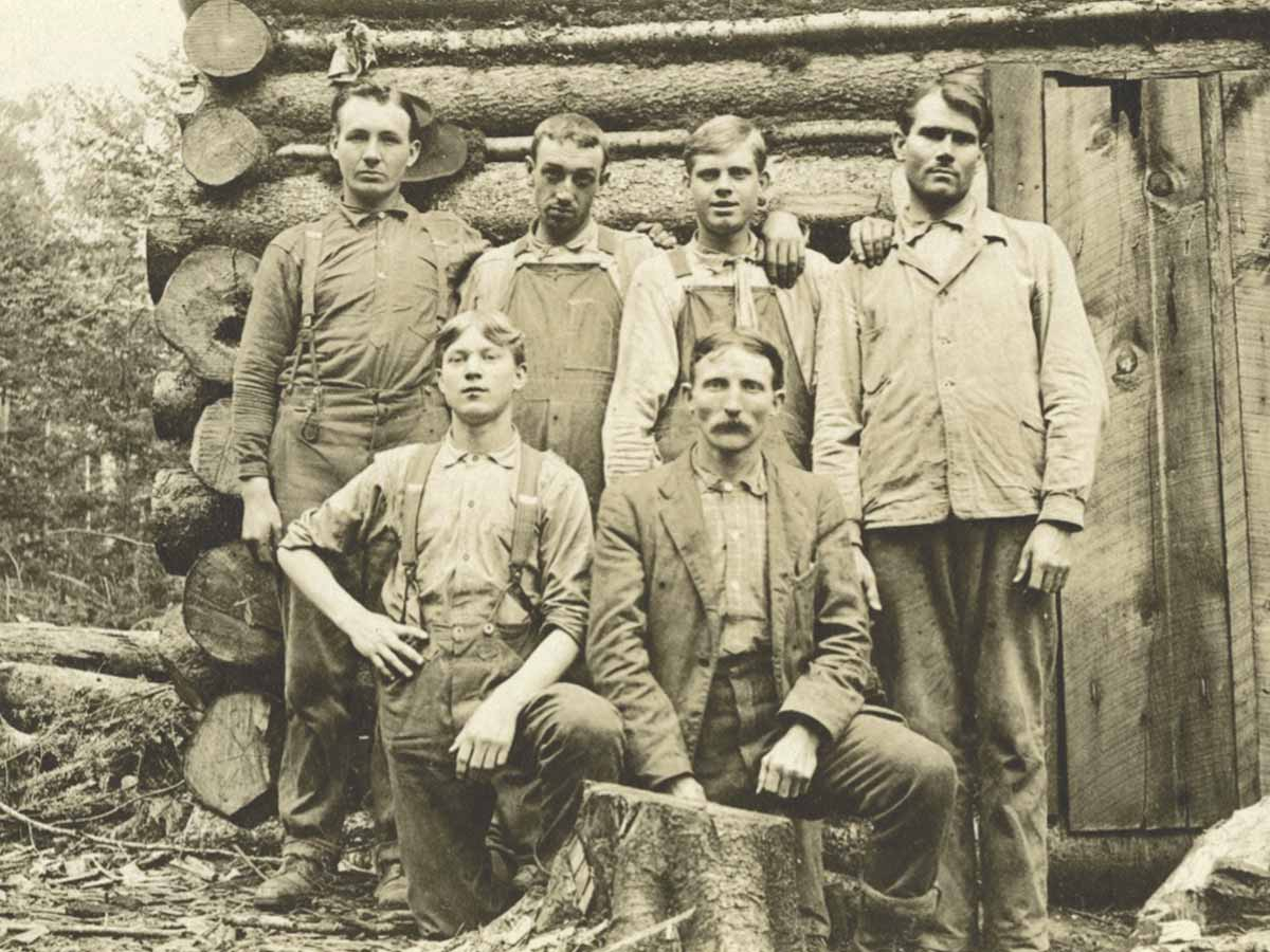 Dr. Carl Schenck is shown here (front row, right) posing with his students at the Boomer Inn cabin. Note that in the left background is the stable where their horses were sheltered. Donated photo
Readers are now likely to be searching their own minds for the meaning of the term “boomer inn.” Could it be a hotel or boarding house? Maybe the name is associated with the generation of people known as baby boomers following World War II.
Then again, it might only be a clever label for the nesting place of the rare red mountain squirrels known as boomers.
The author recently found himself questioning this “boomer inn” handle while studying two old United States Geological Survey maps and tracing a “trail” above Haywood County’s Sunburst Campground. This is the same region known as Three Forks more than a century ago, long before the modern Sunburst Campground era. It is the location where the Middle Prong and Right Hand Prong streams come together and join the West Fork of the Pigeon River. Over the years, Three Forks has hosted an early 1900s logging community with supporting railroad infrastructure, a U.S. Army encampment during World War I, and the Civilian Conservation Corps in the 1930s.
A broken line on the 1935 maps depicts the trail with its meandering westward route from a CCC camp at Three Forks all the way up to the crest of Lickstone Ridge, at an altitude of 5,600 feet above sea level. The trail climbs along the lower reaches of the Right Hand Prong stream to the point where the waters of a smaller tributary named Boomer Inn Branch empty into it. From there, it generally follows Boomer Inn Branch up the mountain to Double Spring Gap at the top of Lickstone Ridge.
Interestingly, less than a mile below Double Spring Gap, the early map indicates an existing structure beside the trail with the label “Boomer Inn.” To a keen reader of maps, this structure located at such a high elevation in the middle of an unpopulated wilderness area and with such an unusual place name begs the questions, what is Boomer Inn and is it still there?
That is what the search for Boomer Inn is all about. Those of you whose interest might be aroused are invited to read further into the matter and learn more about this Boomer Inn conundrum.
Related Items

Meet Revolutionary War general at Haywood County Library

Botany, beauty and Bartram: The flower hunter's legacy

Word from the Smokies: All hands on deck to rehab a rugged Appalachian Trail section

Tell the left-wingers it’s hands off
Biltmore Forest School
Most Western North Carolinians have heard of George Vanderbilt and his Biltmore Estate in Asheville, but they may not be familiar with Carl A. Schenck. A German by birth and training, Schenck earned a Ph.D. in forestry sciences in early 1895. That same year, he was hired by Vanderbilt to take on the forestry management responsibilities for Vanderbilt’s Biltmore and Pisgah Forests, covering more than 100,000 acres.
Three years later, in 1898, Dr. Schenck opened a school of forestry named the Biltmore Forest School. It was the first of its kind in the United States, with daily morning lectures and afternoon horseback trips into the forests to instruct students in the basics of forestry sciences.
Unfortunately, Dr. Schenck’s services at Biltmore were terminated by Vanderbilt in 1909, and he, along with his wife and forestry school, were forced to move off the property. Reuben B. Robertson, who was the manager of Champion Fibre Company’s new pulp mill at Canton, soon became aware that Dr. Schenck had no place to take his Biltmore Forest School students. Consequently, Robertson invited Dr. Schenck to bring his forestry school over to Champion’s new logging village named Sunburst, in Haywood County. The village was woefully underutilized at the time, pending the start of logging operations in the company’s vast forest lands surrounding Sunburst, on the headwaters of the Pigeon River. Financial issues had thus far delayed completion of Champion’s railroad, Pigeon River Railway, linking Canton to Sunburst, leaving no cost-effective means to transport harvested timber to the pulp mill in Canton.
A grateful Dr. Schenck gladly took Robertson up on the offer, and for a few months of each year, from 1910-1913, Sunburst’s new schoolhouse/church building boasting a wonderful belfry hosted the Biltmore Forest School. Dr. Schenck and his wife were provided a comfortable home to live in and his students were lodged in available houses and tents.
As it happened at the time, on the other side of Lickstone Ridge, a few miles west of Sunburst and beyond Double Spring Gap, Champion had recently purchased the Quinlan-Monroe Lumber Company. Included in the acquisition were a circular sawmill and extensive forests on the headwaters of Allen’s Creek, embracing several large bodies of spruce timber.
This situation offered a unique opportunity for the Biltmore Forest School students to travel over the mountain and study Champion’s methods for accessing and removing the spruce timber from mile-high elevations. These logging efforts would eventually include the construction of railroads, log chutes and flumes, splash dams, and even a Roebling Engineering Company incline railway system.

- Biltmore Forest School students are huddling to study the Roebling Engineering incline railway installation at Champion Fibre Co’s. logging operations near Double Spring Gap (1912).
The Boomer Inn
Dr. Schenck and his students traveled by foot and on horseback from Sunburst to the former Quinlan-Monroe properties beyond Double Spring Gap, where Champion Fibre Company was logging. There, they were able to observe and participate in the various forestry operations employed in cutting, removing and processing spruce timber.
It was a long, strenuous journey to climb the steep mountain slopes to Double Spring Gap. Old and even recent USGS maps illustrate the zigzagging trail route Dr. Schenck and his students likely used — one that is several miles long and gains more than 2,000 feet in elevation. Obviously, the zigzagging course up the precipitous mountain slopes was necessary to maintain a grade that man and horse could reasonably negotiate.
The trip from Sunburst across Double Spring Gap to reach Champion’s logging activities would have taken at least two hours. It is reasonable to presume the students had a camp somewhere along the way for respite and overnight lodging. This would have benefitted those travelers who were either late leaving or returning to Sunburst, or who were needing rest or shelter from inclement weather. It would also have provided a haven for the forestry students engaged in multiple-day projects at the logging sites across the ridge.
As a matter of fact, there is an existing photograph of the campsite used by Dr. Schenck and his students. It shows the professor posing with five of his future foresters in front of a very rustic log cabin. Of note, the cabin’s foundation logs — or sill logs — rested directly on the ground. Also, the materials used for chinking — or filling — the spaces between the cabin logs were slender poles and what appears to be a mixture of mud and moss. The main entry door was made from two vertical wood planks with hinges that look to be fashioned from chunks of leather.
Near the log cabin was an even more rustic pole structure with a sort of canvas fabric used for the roofing. A surviving photo reveals this rough assembly of sawn trees served as a stable and was large enough to have sheltered several horses along with hay and other feeds.
Could these hastily constructed structures be the Boomer Inn that is represented on the 1935 USGS Waynesville Quadrant map? That would be the same Boomer Inn shown situated near Boomer Inn Branch on the trail to Double Spring Gap.
It certainly seemed to be a good possibility — good enough to inspire the notion of attempting to locate the actual Boomer Inn site in the field. An inspection of the physical site shown on the map would at least determine if the terrain offered a suitable venue for the log cabin and stable. Although unlikely, there was even a remote possibility that surviving remains or other evidence of the structures might be discovered.
Hence, the present-day search for Boomer Inn began.

- This 1935 USGS map shot (Waynesville quadrant) shows the upper section of the trail that connected the Sunburst logging village, where the Biltmore Forest School was located, to Double Spring Gap. The “Boomer Inn” is clearly indicated and apparently still existed at the time. The lower section of the trail is illustrated on another 1935 USGS map (Sam Knob quadrant). Donated photo
Searching for the Boomer Inn
It was a wonderful day in late October that found me and my fly-fishing buddy, who is an excellent woodsman, wandering through the forest wilderness, far above Haywood County’s Sunburst Campground. As the sunlight streamed through the remaining leaves on the trees, the red, orange, and yellow fall colors shown brilliant. Temperatures ranging from the upper 30s in the morning to the 50s in the afternoon made conditions ideal for hiking the old trails, railroad grades, and logging roads in search of the Boomer Inn.
As it happened, bear-hunting season was underway in the Pisgah Forest. When we arrived at Sunburst Campground on North Carolina Highway 215, the gate across United States Forest Service Road 97 was unlocked and the road was open to vehicular traffic. With raised spirits, we began motoring alongside the beautiful mountain stream known as the Middle Prong. After adventuring about 1.3-miles up the Forest Service road, we encountered two consecutive and very tight switchbacks in the road. These are the same switchbacks that steam locomotives pulling logging cars utilized in the early 1900s.
The Forest Service road veers away from the Middle Prong after the switchbacks and winds its way around the mountain slopes until reaching a bridge crossing of the Right Hand Prong stream. We crossed this bridge and not long after drove through a fording spot on Boomer Inn Branch, eventually reaching the unmarked hiking trail 97D on the left side of the road. At last, after a 5-mile or so drive, we parked the truck beside the road and got started up trail 97D toward Double Spring Gap.
Boomer Inn searchers, be forewarned that for most of the year—January through September—FR97 is closed to motor vehicles. In that case, you will have to take a brisk one-hour hike up the Right Hand Prong stream along trail 97B until it eventually intersects with FR97. Just across the roadway is the 97D trailhead that will allow you to continue the search for Boomer Inn.
The hiking trail 97D is unmarked in the field but clearly shown on the Sam Knob (2019) USGS map. Also, a continuation of the trail to Double Spring Gap is plainly illustrated on the Waynesville (2019) USGS map, although the mapmakers failed to label it. Searchers are advised to track their progress on these maps using a cellular phone downloaded with Avenza Maps or similar hiking apps.
In less than a quarter of a mile after starting the trek along trail 97D, we encountered a fork in the old logging grade. The lower trail is the one indicated on the map and, likely, the one used by Dr. Schenck and his forestry students. However, both trails eventually merge again, so you cannot go wrong whichever one you take.
Searchers should be aware that trail 97D is not a maintained trail, and there will be numerous deadfalls to wade through, climb over or go around. Please be careful and protect your eyes from the stiff limbs and brush that you will sometimes need to bust your way through. Although it was obvious that much of the trail was graded and used by railroad and truck logging crews in the past, there were other sections that were probably used only by Schenck, his students, sporadic hiking and hunting enthusiasts, and the wildlife. Due to erosion and tree falls over the years, these can sometimes be hard to discern and follow. So, searchers, take your time and, if you’re using a tracking device, check your location often to make sure you are still on or close to trail 97D.
The first half-mile or so of the trail gradually leads in a westerly direction and climbs approximately 400 feet in elevation before crossing an unnamed creek. After the creek crossing, the trail begins a zigzagging path up the steep mountain slope between the unnamed stream bed and Boomer Inn Branch to the west. We crossed the unnamed creek and began plodding uphill while negotiating five switchbacks and gaining approximately 640 feet in elevation. Eventually, we found ourselves in the vicinity of the suspected Boomer Inn site.
The old 1935 Waynesville USGS map indicates the Boomer Inn was located near a point on the trail having a shape much like a bird’s head—at least it looks like a bird’s head to me. In fact, the modern Waynesville USGS map (2019) illustrates the trail with this same bird’s head shape, and the beak is situated at the 5,000-ft elevation contour. My friend and I chose the tip of the beak as the point to begin searching for a site where Dr. Schenck, his students, and their horses could have sheltered overnight—the site of the Boomer Inn.

- A view of Sunburst village with the impressive schoolhouse/church building on the right. This is where the Biltmore Forest School held classes a few months each year from 1910 through 1913. Donated photo
A key find, perhaps
At the age of 72 years, the author does not usually make strenuous and difficult excursions into the wilderness alone. So it was good that I had recruited my fly-fishing buddy to be my Boomer Inn search companion on that fine day. As soon as he and I reached the 5,000-foot elevation and the tip of the bird’s beak, we spread out and began looking for expansive and reasonably flat areas that could have possibly hosted a small log cabin and horse stable.
The actual field conditions we encountered were exactly as shown on the topo map. Among the scattered spruce and deciduous trees, there was only one good-sized, relatively flat area that stood out to us. It was located between a towering domed hill on the upper side and a steep mountain slope below. We envisioned various ways the log and pole structures might have been arranged on this site, and how easily it could have been accessed from the trail. Although other fairly level but smaller areas were found, none would have been as accessible or suitable for accommodating the forestry students’ encampment.
We looked around for remains or evidence of the old Boomer Inn structures, but failed to find anything. Mother Nature and more than a century of decay had eliminated the wooden structural elements. Of course, there is the possibility that small artifacts still exist, hidden somewhere in the undergrowth or buried in the ground. Since neither of us are archaeologists, we decided to forego excavations that might reveal a rusty nail or even a coin or lost folding knife left behind by one of the students. One day, I hope someone will have the motivation and gumption to search for and find treasures such as these.
The fact that my friend and I saw no rotten cabin logs or pieces of decaying canvas roofing lying around on the ground changes nothing in our minds. We believe the site where Boomer Inn was likely located has been discovered. For those interested in plotting this Boomer Inn location on a map (for instance Google Maps) or needing additional guidance, we offer these geographical coordinates: N35.376569 degrees and W82.967501 degrees.
By the way, I suspect the name “Boomer Inn” was not derived from the small red mountain squirrels — or boomers — that dwelled in evergreen trees at the higher elevations. There is a good possibility the inn took its name from one of the definitions the word “boomer” had at the time: “an itinerant or migratory worker,” or “a transient worker.”
Considering their many back-and-forth trips between the school at Sunburst and the logging operations on the far side of Double Spring Gap, the Biltmore Forest School students would surely have thought themselves to be boomers. They would have been proud of their migratory endeavors to learn more about forestry science — proud enough to give their rustic quarters at Double Spring Gap the name “Boomer Inn.”
Note to Boomer Inn searchers: Please be aware that if you are undertaking a similar quest to find the Boomer Inn site this hike is not an easy one. That is especially true if you are beginning the trek from the Sunburst Campground. The hike is strenuous and tiring, and you will have to scramble often and carefully to get around all the deadfalls and stay on course. Yet it can be rewarding as well. In addition to the Boomer Inn site, we discovered the possible site and remains of an old logging splash dam and a few significant steam locomotive artifacts, which appeared to be drive mechanisms.
(Carroll C. Jones was born and raised in the papermill town of Canton, located in the heart of western North Carolina’s mountains. He is descended from the Hargrove, Cathey, Shook, Moore, and Crymes families who pioneered Haywood County. His latest book is titled “Thomson’s Pulp Mill: Building the Champion Fibre Company at Canton, N.C.—1905 to 1908.” Find out more about Carroll and his books at carrolljones.weebly.com.)