The flood timeline
 U.S. Geological Survey data shows how high the river crested at an observation station located about 1.1 miles past Jukebox Junction on the East Fork Pigeon River.
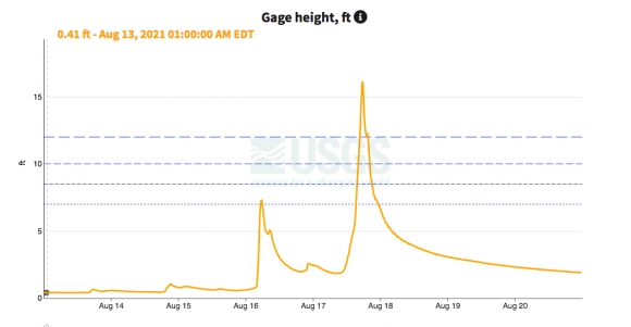
Friday, Aug. 13. Rivers are at normal levels, with a gauge about a mile upstream from Jukebox Junction on the East Fork Pigeon River reading 0.4 feet at 8 a.m., while a gauge on the Pigeon River just outside of Canton reads 1.61 feet.
Sunday, Aug. 15. Weekend rains cause the rivers to rise, with the East Fork gauge reaching a peak of 7.28 feet — just below the flood stage threshold of 8.5 feet — at 5:45 a.m. Sunday, Aug. 15. Downstream at the Canton gauge, the peak of 8.26 feet comes at 7:30 a.m. Monday, Aug. 16.
Monday, Aug. 16. River depth declines over the course of the day as sunshine returns. The East Fork gauge reaches a low point of 1.83 feet at 8:45 a.m. Tuesday, Aug. 17, and the Canton gauge falls to 2.89 feet by 9:45 a.m. Aug. 17.
1 p.m. Tuesday, Aug. 17. Rivers rise amid heavy rainfall. By 1 p.m. the depth at the East Fork gauge has nearly doubled to 2.63 feet.
3:45 p.m. Aug. 17. The East Fork gauge reaches flood stage, measuring 8.54 feet.
4:45 p.m. Aug. 17. With a depth of 12.01 feet, the East Fork is in major flood stage. The Pigeon River at Canton enters flood stage with a depth of 10 feet.
Related Items

State sees widespread moderate drought

Crews work toward expedited repair of Newfound Gap Road

North Carolina is drought-free for the first time since October 2024

Application period open for crop loss disaster assistance in 2024: Farmers urged to sign up by the May 4 deadline
5:45 p.m. Aug. 17. The East Fork flood crests at 16.15 feet, well beyond the previous record of 13 feet set in 2004.
7 p.m. Aug. 17. Canton reaches moderate flood stage as the Pigeon River measures 15.5 feet.
8:15 p.m. Aug. 17. The waters crest in Canton, with the gauge measuring 19.76 feet.
Wednesday, Aug. 18. Hour by hour, the waters recede. Canton exits flood stage at 12:30 a.m., and the East Fork location exits flood stage at 9:15 p.m. Aug. 17. By 5 p.m. Aug. 18, the East Fork gauge measures 3.47 feet and the Pigeon River gauge measures 4.47 feet.
Tuesday, Aug. 24. Water levels remain higher than they were Aug. 13 but maintain a slow downward trend. As of 10 a.m., the East Fork gauge measures 1.21 feet and the Canton gauge measures 2.51 feet.
Figures reported from U.S. Geological Survey gauge data and interviews with the National Weather Service Forecast Office in Greenville-Spartenburg, South Carolina.