Haywood remains poised for more landslides
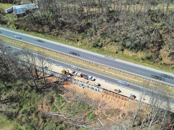 An aerial photo shows a landslide in Waynesville just off U.S. 74. A Shot Above WNC photo
Working in municipal government, one often encounters geographic challenges that exist in some areas, but not in others.
“I come from Burke County, and there is some mountainous terrain there, but of course it’s nothing like here,” said Haywood Emergency Management Director Greg Shuping. “It’s not a secret that we’re probably going to be more prone to landslide hazards than others.”
Western North Carolina has seen a slew of slides over the past three months — including a high-profile incident on Interstate 40 that briefly closed the highway and made national news — but more than a few of those took place in other locations around Haywood County, including in Waynesville.
Waynesville’s Town Manager Rob Hites, who’s enjoyed a long career mostly down east, said he’d never really had to deal with the phenomenon until he came to work in the highest elevation county east of the Mississippi River.
“I found out the most feared thing a transportation engineer can deal with in the western part of the state is a landslide, whether it be rock or soil,” said Hites. “What happens is, the soil gets so super-saturated that it slides off the rock shelf it resides on, and if the city has built a road where the slope beside the road is less than a 45 degree angle, it naturally slides. That’s just the way physics works.”
Heavy rains so far this year have left soils saturated for long periods of time, meaning that conditions have been ripe for landslides; data from the National Oceanic and Atmospheric Administration show that the first quarter of 2019 was exceptionally damp for Haywood County.
Related Items

Federal failures cast shadow over Haywood budget

Grants available through Haywood Health Foundation

Haywood Farm Bureau scholarship deadline nears

Innovative middle school applications open: Haywood schools expand early college model
In January, the county saw precipitation of between 6 and 8 inches, up to 150 percent of historic totals. February was even worse, with 8 to 15 inches of precipitation coming in at 150 to 300 percent of average. March was more in line with traditional expectations, but still at about 110 percent of normal.
Through April 9, Haywood’s already received about two-thirds of the precipitation it should receive for the entire month, just as WNC enters the rainiest part of the year through September.
“It was just an influx of rain, which is not unprecedented here in the mountains,” Shuping said. “It caused and triggered some landslides. I don’t remember how many we had, but they were all about the county. The one on Paradise Lane was the one we focused on quite a bit, because for a time it isolated the residents that were living on the other side of it.”
Other slides, Shuping said, didn’t directly impact people travelling to or from work.
Haywood’s not totally helpless, though; in a county where this sort of thing happens a few times a year, Shuping’s department has a number of resources at its disposal.
“We are blessed here with our own internal erosion control specialists at the county level, and that’s unique because of our volume of landslide activity,” he said. “Other counties have to lean exclusively on the North Carolina Geological Survey. I can go meet with [Haywood’s specialists] on a daily basis if I want to, and learn about the geology of the county and how it affects emergency response. That’s a huge blessing that not everybody has.”
Another thing that not everybody has — in fact, almost nobody has — is a plan to respond to landslides.
“What we created was a landslide response plan for Haywood County. As emergency management we do try to plan ahead, and we do try to predict the things we can control — what do we do if and when the conditions are ripe for landslides? What we learned was, there are trigger points to determine if the likelihood is high for a landslide,” said Shuping. “For example, 4 inches of rain in a 24 hour period — we’ve learned that that’s a trigger.”
Landslide response plans are so rare that Shuping said he had trouble even finding an example of one.
“Like all good planners, we tried to find a plan to kind of mirror ours after, because we don’t want to start with nothing,” he said. “Guess what we found? Nobody has one. I even contacted Ventura County, California, because of the La Conchita landslide years ago, and they didn’t even have one.”
The La Conchita slide killed 10 people in 2005, after a 1995 slide caused major property damage on the same site.
“We kind of broke the mold there,” said Shuping of the plan’s creation. “I wouldn’t call it real high-falootin’ or comprehensive, but man, it works great for us.”
That, combined with soil map layers in the county’s GIS system, allow emergency responders to be prepared; the plan outlines each agency’s role — from law enforcement to fire suppression to erosion control and paramedics.
“When we see heavy rain, we can look at soil layers and disturbed areas and historical landslides from a GIS perspective and we can at least know that those are the high likelihood areas,” he said. “Now, that doesn’t mean it’s going to happen, but does give us a point to start with.”