Through the raincloud: Agricultural community takes stock after record-breaking rains
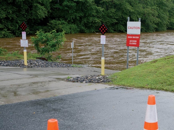 The Jackson County Greenway and boat put-in were blocked off last week due to danger from the swollen Tuckasegee River. Holly Kays photo
A month of rain capped off by the arrival of Tropical Storm Alberto has caused massive flooding, landslides and loss of life in North Carolina’s western region, but the mountains west of Asheville were mostly able to escape the devastation experienced in Polk, McDowell, Avery and Buncombe counties.
“I think everyone’s optimistic that we dodged a bullet to have got 20 inches of rain in two weeks and not gotten any more extensive flooding than what we had,” said Joe Deal, agriculture extension agent for Macon County Cooperative Extension.
According to volunteer-collected data through the National Weather Service’s Community Collaborative Rain, Hail and Snow Network — referred to as CoCoRaHS — the Franklin area received 7.59 inches of rain between May 20 and June 3, while the Highlands area received 17.95 inches. The National Weather Service’s furthest-west official weather station, in Asheville, recorded 14.68 inches for the month of May, a record-breaking number. That rainfall drowns the previous May record of 9.18 inches, set in 2009, and makes May 2018 Asheville’s wettest month on record since August of 1940, when the city received 13.75 inches. Climate records for Asheville go back to 1869.
“This is an unusual event for this time of year,” said Lisa Leatherman, Duke Energy’s local government and community relations manager for the six western counties. “It’s unusual that we’ve had a named tropical storm prior to today. Really the kickoff for the hurricane season is June 1.”
May had been a wet month from the get-go, but rainfalls coming in from Alberto tipped the scales from manageably wet to historically wet. Up until Alberto, said Leatherman, Duke Energy reservoirs in the Nantahala region had been able to capture all the runoff and pass it through the generators, but when Alberto came through lake levels began to climb, nearing the maximum allowed by Duke’s operating agreement.
In Lake Glenville, for example, the target elevation for May is 97 feet with a normal minimum of 95 feet and normal maximum of 99 feet. During the month of May, levels were over the 99-foot maximum for four days and over the target elevation for 27 out of 31 days.
Related Items

How did we do it: Graham Sharp of Steep Canyon Rangers

Following Helene, Big Pillow Brewing crafts its next chapter

Sensing opportunity, Dems lining up to run against Edwards

Hogs and hammocks: Inside this resilient Smokies farm stay
“To maintain that (target elevation) we have to open spillways to maintain flows beyond what pass through the generators,” Leatherman said. “That triggers increased inflows into the main stem of the Tuckasegee River, greater than what the general public and the recreating public see when we’re just running water through our generators.”
The rains caused Duke Energy to open gates on all of its hydro facilities in the Nantahala area, including on Lake Glenville, something that doesn’t happen very often. In fact, the last time Leatherman can remember dealing with this much water was in 2004, a year of hurricanes that caused massive flooding and landslides in the mountain region.
“We’ve been fortunate,” said Leatherman. “We’ve been fortunate in the fact we’ve had saturated soils and we haven’t had any winds, which has been good for our power delivery side.”
The Tennessee Valley Authority has also been responding to the abnormally high water levels, over the past weekend increasing releases from Fontana Dam through the turbines and both spillway tunnels at a rate of 16,700 cubic feet per second. TVA anticipates that the spillway tunnels will stay open until the middle or end of this week.
While Deal, like Leatherman, thinks the mountains came through the storms much better than they could have, the rainy weather is not without impact.
“On my farm we threw away about 75 percent of the (straw)berries that we picked last week,” he said. “That was pretty tough, but to keep picking we had to get those rotten fruit off the vine.”
Macon County farmers saw some minor flooding on the Little Tennessee River, mostly affecting hayfields and pastures, Deal said, but the Cullasaja River didn’t flood at all. Crops like Deal’s strawberries weren’t damaged due to flooding but rather because of diseases spurred by the unrelenting wetness.

Water shoots through open spillways at Fontana Dam. Joshua Moore photo
And while it’s never easy to lose a crop, Deal’s well aware that others have fared much worse. In Clay County, the TVA opened up the floodgates of the Chatuge Dam, flooding several Hayesville farmers. When floodwaters reach the edible portion of a plant, farmers are required to destroy the crop due to sanitation concerns.
“That makes it hard, especially on small farmers, where it makes it more imperative for the local community to come out and support them and buy from them when we have tough times like this,” said Deal.
In addition to direct damage from flooding and moisture, the recent weather has slowed down production and made it hard for farmers to get into the fields to plant or replant. Hayfields, for instance, should have had their first cutting some time ago, but that’s proven impossible.
“The hay crop has definitely been hit,” said Rob Hawk, Cooperative Extension director for Swain and Jackson counties. “It’s rained the last two weeks off and on, and there’s been no time they could really cut and lay the hay down to bale, much less dry. So that hay crop is beyond maturity, and when it goes beyond maturity, it loses nutritional value.”
Still, many farmers have stored hay from last year, which was a good hay year, and even if the nutritional value isn’t what it should be the animals will still have food to eat. Things aren’t as bad as they could have been, and in Jackson and Swain counties the impacts were even lower than in Macon — there was no flooding, just ponding in the fields from direct rainfall, Hawk said, and he hasn’t heard from any farmers who have outright lost a crop.
“We haven’t heard of anything really bad. Don’t know about the tomatoes,” said Hawk. “Those have been out just a little while. We’re worried about possible blight with the wet soil and wet saturated air. That’s always a possibility with tomatoes, but nobody’s mentioned any of that yet.”
While there seems to be a good deal of optimism in the air among Macon County’s agricultural community, said Deal, the fact is the past month has been just Act One of a much longer growing season. Everyone seems to be bouncing back fine, but the future is unknown.
“It’s a long way till the end of this season, so it’s kind of hard to judge from just one event,” he said. “There’s still a lot that can go wrong between now and the end of the season.”
Water quality can recover quickly from flooding
As floodwaters subside and swollen rivers return back to more normal flows, Black Mountain-based Environmental Quality Institute will be keeping an eye on how water quality recovers.
The organization uses volunteers to collect about 160 water samples in Western North Carolina each month, which are then analyzed for eight different chemical tests, adding to an existing 28-year dataset.
If history is any guide, water quality will be able to recover swiftly from any impairment caused by flooding. After the 2004 hurricane season, the Environmental Quality Institute conducted a study of water quality that revealed most Western North Carolina rivers and streams to have surprising resiliency, with chemical concentrations and aquatic organism populations showing little to no change over the next year.
By 2005, sites that had previously earned excellent water quality ratings were still excellent and sites that had earned poor ratings remained poor. In areas with excessive land disturbance, streambank erosion led to higher sediment and nutrient concentrations, though in some cases floodwaters scoured streambeds, leaving less sediment to enter the water column during subsequent heavy rains.
Heavy rains can also lead to cooler lakes with a higher dissolved oxygen content, which is beneficial to aquatic organisms. That’s because, while it can take more than a year for water to migrate out of a lake, heavy rainfall and flooding accelerate the process to the point that a large percentage of the water can be replaced within a month. However, flooding can also bring in large amounts of sediment, reducing water clarity and lake storage volume.
A detailed report is available at www.eqilab.org/vwin/pdf/hurricane-project-eqi.pdf.