The crossroads of humanity and nature
I like visiting those sites here in the Smokies region where there is what I think of as an “overlay;” that is, places where both natural and human history commingle. At such places, one encounters the confluence of all or several of the major strands in the region’s natural and cultural fabric: wild areas, plants, and animals; early Cherokee and pioneer settlement influences; and the impacts of the modern era, initiated here primarily with the coming of the railroad in the late 19th century. At such places, the alert observer can experience what the French have defined as “frisson” — a moment of excitement and insight that arises when various forces coalesce.
One such place exists along the lower portions of the Kephart Prong Trail (KPT) in the Great Smoky Mountains National Park. The trailhead is situated at a bridge on the right side of the Newfound Gap Road (U.S. 441) about seven miles above the Oconaluftee Visitors Center.
Kephart Prong is a small stream so-named because it flows from its headwaters on Mt. Kephart into the Oconaluftee River near the trailhead. The KPT extends two miles from 2,750 feet to its junction at 3,600 feet with the Sweet Heifer and Grassy Branch trails, where the KPT shelter is situated. One guidebook accurately describes the KPT as “a riverine stroll.” Unless you’re disabled in some manner, it is quite doable. If for whatever reason you’re not up to the full 4-mile roundtrip, the first mile or so will provide plenty to see and think about.
Kephart Prong is a beautiful creek, not so expansive as Hazel or Deep creeks elsewhere in the park, but with a vivacity all its own as it plunges and tumbles over huge boulders and forms rivulets in the main and side channels. Unlike most of the creeks in the park, there are numerous areas along its lower portions where the stream has at high-water levels formed bends and oxbows that become mucky sloughs during normal stream flow.
There are numerous trees and shrubs of interest, including oil-nut, witch-hazel, strawberry-bush, three maple species (striped, red, and sugar), and three species of deciduous magnolia (cucumber, umbrella, and Fraser’s). A good-sized tulip tree can be located just to the right of the KPT a short distance from the trailhead.
Related Items

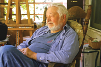
Writer and naturalist George Ellison dies at 81

George Robert Ellison II — Thoreau in a jockstrap

Renowned artists conserve their life’s inspiration

Snakes, really, are beautiful creatures
But there are other sorts of non-native plants that indicate human activity on a large scale. About a quarter mile above the trailhead, you’ll commence spotting large boxwoods and a stand of arborvitae. Company 441 of the Civilian Conservation Corps was stationed here from 1933 to 1942. An old pump, a low stone wall, a masonry “message board,” a hearth, pieces of pipe, and a 20-foot-high chimney are just some of the material evidence left over from those long-ago days.
From the late 1930s into the early 1940s, 23 CCC camps were established in the park, which was officially founded in 1934. At the time of peak enrollment (1934-35), 4,350 men worked for the CCC out of military style camps. They were paid $30 a month, with $25 of that being sent home to their families. “The CCC boys” were noted for their fine work, much of which is still in evidence today.
All in all, Company 441 (comprised of about 200 young men at any given time) improved 20 miles of primary and secondary roadways; constructed 65 miles of trails; 22 fish-raising ponds; a water system for Newfound Gap and parking areas for 600 cars; and planted 100,000 or so trees in the immediate area that had been denuded by logging activities.
At about half a mile above its trailhead, the KPT passes through a thicket of rosebay rhododendron and crosses a footbridge over Kephart Prong. Alongside the trail, several hundred yards up the slope from this bridge, you’ll spot the remains of what was once an extensive fish hatchery (rainbow trout and smallmouth bass) established in 1936 by the federal Work Projects Administration (WPA). An old photo of the fish hatchery shows several buildings, a house, and 25 or so rock-rimmed fish ponds, each about 10 feet in diameter. Established to supply game fish in the park as a part of the growing tourist economy of Western North Carolina, the facility hatched a half-million trout eggs in December 1936 alone. A large concrete platform, a cistern, and two concrete tanks are all that remain today of that operation.
A mile above the trailhead, you’ll cross another footbridge on your way to the KPT shelter. In places, the KPT traverses a railway bed constructed by the Champion Fiber Company in the early 1920s. At that time, the area was alive with loggers, Shay locomotives, switchbacks and steam-powered overhead skidders.
As I noted, the KPT provides much food for thought, a “frisson” between the past and present states of a mountain watershed. Much has taken place here — some of it very good, some of it dubious at best. But all of it is part and parcel — an “overlay” — of the ongoing history and legacy of this immediate region. I’m of the opinion that it’s fruitful to walk such trails from time to time and mull things over.