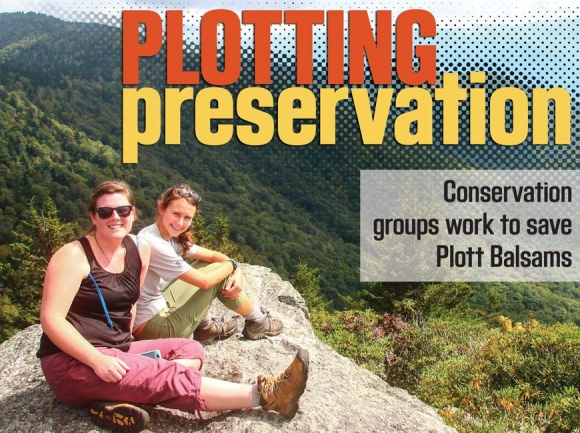
Worth protecting: Conservation organizations partner to preserve Parkway lands
Born in the upstairs of the Post Office building his mom ran in Crabtree, Robert Williams, now 87, has always called Haywood County home.
His dad was in the cattle business, and when the family moved to Canton during Williams’ childhood, chores such as feeding cattle, splitting wood and tending the fire kept Williams busy. But his grandfather William Silver’s 1,800-acre tract in the Plott Balsams, while also technically a workplace, provided a respite from the busyness of day-to-day life. Silver and his son — Williams’ uncle — ranged cattle up there, and in the summers Williams would join them.
“We’d go up there and spend nights in the old cabin,” Williams said. “I remember a lot of tales being told in there when I was a kid.”
They called the cabin Camp WiHaSi, a combination of the family names Williams, Hawkins and Silver.
SEE ALSO:
• Community envisions Plott Balsams’ future
• Elk habitat projects underway on Silver Game Lands
“We spent a lot of time on there,” added Williams’ cousin Thornton Hawkins, 88, who now lives in Asheville. “I guess you’d say we had a romantic attachment to it.”
Related Items

GSMNP Superintendent talks visitation, parking tag program

GSMNP to improve Gatlinburg entrance

American Sign Language Day programs offered at Cades Cove

Parking fees generate $10 million
Later, as an adult, Williams would inherit his section of the land — hundreds of acres of forest abutting the Great Smoky Mountains National Park.
In the years between his childhood on Sheepback Mountain and his acceptance of the inheritance, Williams had traveled the world. He served four years in the military, fighting in the Korean War, and he’d been all over the United States — even living in New Jersey for a spell — before returning home to North Carolina.
“I think this is the best place in the country as far as I know, and we traveled all across the country,” he said.
Upon his return, Williams built the Meadowbrook Resort on 10 acres of the family land, raised a family and 18 years ago found himself — a man who had never ridden a motorcycle — owner of Crazy Bob’s Biker Stuff on Dellwood Road. Williams holds four patents and can still be found manning the cash register at Crazy Bob’s, radio in the background.
As the years wore on, planning for the future of the 783 pristine acres in his name began to seem anything but crazy to the owner of Crazy Bob’s.
“More land doesn’t keep appearing,” said Williams’ daughter Karen Collis, 61. “It just keeps disappearing. Its use is really important because down the road you want your kids and grandkids to be able to walk out and take a hike, go for 4 miles and not see any people or houses or phone lines or anything like that, to wander across a bear or something that’s wild and living.”
Investors had been knocking for years, wanting to buy Williams’ land for some future development. But Williams kept saying no, eventually selling his property to The Conservation Fund for roughly half its market value, with the goal of eventually turning it into a game preserve managed by the N.C. Wildlife Resources Commission.
Eventually, more of Silver’s descendents followed suit — including Hawkins — and now the property that Silver purchased in 1907 is conserved within the 1,925-acre William H. Silver Game Land.

Collaborating for conservation
The Silver Game Land, officially created in February 2017, represents a major win for wildlife and land conservation. But it’s far from being the only conservation project underway in the Plott Balsams.
“We’ve got a ways to go, but in the future it could be possible to walk out of your cabin or motel room in Maggie Valley and get on a trail and hike up to Plott Balsam and Waterrock Knob on lands that are owned by a combination of local, state and federal agencies,” said Bill Holman, North Carolina director for The Conservation Fund.
The Conservation Fund, along with a group of other nonprofit organizations, has been working for years towards a larger vision of land conservation along the Blue Ridge Parkway — especially the high-elevation section stretching from Maggie Valley south to Waterrock Knob.
The Blue Ridge Parkway, which is consistently one of the most-visited units in the National Park Service, is a bit of an anomaly in that its 469-mile span is routed to capitalize on the breathtaking views afforded by the Blue Ridge Mountains — but throughout much of its length, the buffer of National Park Service land is quite skinny. Often, the Park Service boundary sits 400 feet or less from the roadside.
“For the most part, it is a pretty narrow ribbon of land,” said Rusty Painter, executive director of the Conservation Trust for North Carolina. “It is pretty precious and surrounded by private land. Anything can happen unless it’s protected. We’re trying to make sure that the Blue Ridge Parkway doesn’t start to look like I-40.”
CTNC has been serving as North Carolina’s official “Parkway land trust” since the Governor’s “Year of the Mountains” Commission appointed it as such in 1996, and its official mission is to protect as much land along the Parkway’s borders as possible. But the section running through Haywood and Jackson counties has been a particular focus, because the large swathes of undeveloped private land covering the high-elevation spruce-fir forests found there mean that there is much to gain from conservation — and also, much to lose from failing to act.
CTNC is not alone in that realization. For years, a tight-knit group of conservation organizations has been working collaboratively toward the goal of increased land conservation in the Plott Balsams. Its crowning achievement thus far has undoubtedly been the still-pending creation of Waterrock Knob Park, a 5,329-acre addition to the Parkway announced in 2016 stemming from lands donated by The Conservation Fund, CTNC, the Southern Appalachian Highlands Conservancy and The Nature Conservancy.
“The effort has evolved organically among groups that have a good working relationship with one another, and each fulfilled roles that make sense for us,” said Carl Silverstein, executive director of the SAHC. “There’s not a memorandum of understanding, but there’s kind of a natural working relationship.”
Representatives from each of the organizations typically meet once or twice a year, Silverstein said, with subsets of them getting together more often than that. Coordination is important, because there is more than enough work to be done — figuring out which organization is best suited to which project is vital.
CTNC has developed a scientific method of prioritizing efforts. The organization uses a “fairly complex” GIS model to review more than 5,000 properties located within 2 miles of either side of the Parkway, processing them based on factors such as visibility from the Parkway, water quality, natural heritage value, size, climate resiliency and proximity to other protected areas. This information results in a score of one through 10 for each property that’s 10 acres or more, which helps CTNC — and the organizations it works with — figure out where to concentrate conservation efforts.
“We all look at the results together and parse out the different properties and determine who makes the most sense to approach any given landowner,” Painter explained. “We have very limited resources as far as funding goes, and staff time and resources as well, so we want to make sure we’re picking the best of the best to spend the money on.”
Making the deal
Even with clearly identified priorities, the process is anything but straightforward. Some landowners say no. Some say maybe. Some say yes — but that usually requires money.
“We often work with people who have owned that property and would prefer to see it go to an organization like ours rather than a developer, and then at the same time they may have needs for their own lives that compel them to need to sell the property,” Painter said.
Then, the question is — what’s a fair price? Sometimes a deal can be reached quickly. Other times the deal evolves over a course of years of conversations and changing conditions. For example, SAHC had been speaking for years with the owners of a 60-acre tract that will soon be part of Waterrock Knob Park, but they could never agree on a price. The economy was still booming and real estate prices were high — the land trust simply couldn’t come up with the money to compensate the owners like they wanted to be compensated.
“In this case, in the intervening time the economy unraveled and the real estate market dropped so the property sold at auction for a much lower price than we had been looking at having to pay,” Silverstein said.
Even a lower price requires the raising of money, however. Sometimes that comes from donors who believe in a land trust’s mission. Other times it comes from grants. But grants take time, and state monies are a lot tighter these days than they used to be.
“We are very appreciative that the legislature continues to fund the Clean Water Management Trust Fund and the Parks and Recreation Trust Fund,” Holman said. “But the level of funding is not as great as it was in the heyday. The state was investing over $100 million a year in land and water conservation. Now it’s more like $20 or $30 million.”
Other times, land trusts receive outright land donations — and while free is always better, each donation comes at the price of countless hours of behind-the-scenes outreach and relationship building. Earlier this month, CTNC accepted a 21-acre land donation from Florida landowner John Scelfo and George Escaravage, a Waynesville resident, at Woodfin Acres, which will eventually become part of the Waterrock Knob acreage. The organization contacted Scelfo two years ago about acquiring the land, but his price at the time was too expensive.
In the meantime, CTNC spent a lot of time getting to know other landowners in the subdivision, which had excellent conservation value such that the land trust hoped to protect as much of it as possible from development.
“We kind of got a foothold in this subdivision,” Painter said. “The landowners who already do own land in there know us and trust us and understand what we’re doing and are all very supportive of what we’re doing. This guy (Scelfo) eventually decided, ‘I ‘d like to go donate that property.’”
In many cases, the land trust doesn’t see itself as being the end owner of conserved properties. For a lot of conserved land along the Parkway, the ultimate goal is to convey it to the National Park Service, or the N.C. Wildlife Resources Commission, or some other government entity.
But the wheels of government move slowly, so the land trusts prove invaluable middlemen to ensuring transactions go smoothly.
“We can move faster than the government agencies, so we often wind up buying properties and holding them for several years while the public and private funding comes together to make it possible to transfer the property to, say, the Blue Ridge Parkway or the Maggie Valley Sanitary District,” Holman said.
Some parcels in the Waterrock Knob land, for instance, have been in conservation for more than a decade. And while the 2,986 acres donated by The Conservation Fund have been officially transferred to Park Service ownership, the remaining 2,343 acres are still in process, with the last acre estimated to be transferred within the next two years. Before accepting a land donation, the Park Service has to go through a long process of due diligence and approvals — a process too onerous to expect landowners needing to move on with their lives to put up with, but doable for organizations that are in the business of land conservation.
Just the beginning
With recent successes like Waterrock Knob Park and the William H. Silver Game Lands, one could assume that intensive conservation efforts are winding down in the Plott Balsams.
That is not the case.
“There’s still a lot to be protected there,” Painter said. “We really want to continue to add to the Waterrock Knob conservation area by protecting as many acres there as we can.”
The Silver Game Land, also, could get bigger, Holman said — and ultimately, the dream is to create a continuous channel of protected land from Maggie Valley and Waynesville running up the mountainside to the Parkway and then back down again into Sylva.
That dream is not yet a reality. But it’s also a lot closer than a pie in the sky. A few more years, Holman believes, and it could be done. The Campbell Creek watershed, which runs up from Maggie on the east side of U.S. 19, is a key part of that equation, and some funding has already been secured to start acquiring land there. The Maggie Valley Sanitary District would ultimately own the acreage to ensure a clean water supply.
“There’s some stuff happening that’s more preliminary, but I hope to have better connectivity on the Waynesville side as well,” Holman said. “There’s some properties we’ve been talking to people about, but it’s too early to really talk publicly about that.”
Once the conservation part is done, the next task is to figure out how those lands should be managed. The visioning process currently underway at the Blue Ridge Parkway Foundation (see page 30) will be part of that, and construction of a high-elevation trail connecting the communities of Maggie Valley, Waynesville and Sylva has long been part of the idea. Creating such a trail would require extensive cooperation from various government entities, hiking clubs and nonprofits.
The result, should it come to fruition, would be a vast tract of untouched forest covering some of the most rare and high-quality habitat in the Southeast and drawing outdoors enthusiasts of all types to explore what Haywood and Jackson counties have to offer. Such an accomplishment would surely define the counties’ future for years to come — and it would also ensure that the vistas of the past remain unblemished in the public domain.
“We’re lucky to have the Parkway,” Williams said. “You want to get out of the world, just go up on the Parkway, and forget your troubles.”