Up in smoke: Wildfires rage across a bone-dry WNC
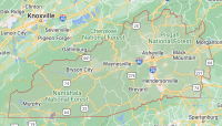
Billowing smoke and inundations of suited-up firefighters have become the norm for many areas in Western North Carolina over the past couple weeks as tinderbox conditions have lured flames across more than 11,000 acres — about 17.5 square miles — of forested land in the Nantahala National Forest and adjacent private property.
And counting.
“If you look at the weather forecast, it’s going to continue to be dry, no precipitation in the forecast,” said Kent Nelson, a forest ranger with Maine Forest Service who traveled south to help the cause in WNC. “I think it’s going to get a little cooler, but it might be a little windier. The wind is not going to help us.”
Wind is the enemy of the firefighter, energizing previously dormant embers and wafting the fire to life again.
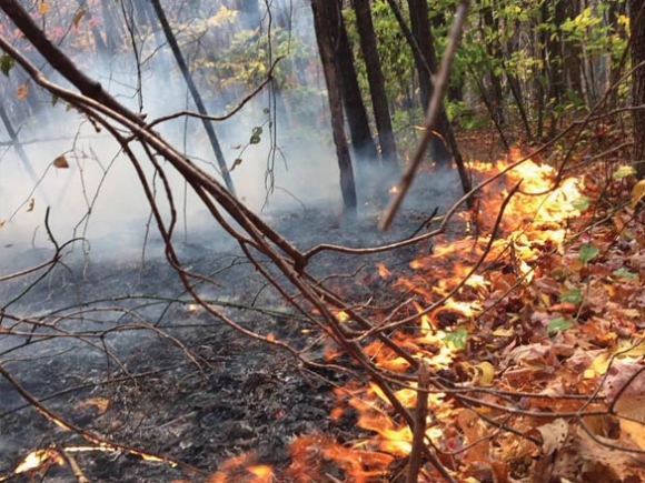
The Dicks Creek fire, for instance, which initially burned 374 acres along Dicks Creek Road just west of Sylva, was all but subdued when wind gusts reignited the blaze. Flames gathered strength from newly fallen leaves covering the previously burned area and grew into a remarkably intense fire that torched treetops and jumped across containment lines. The fire grew to 532 acres overnight and covered 726 acres as of Tuesday afternoon, Nov. 9, after firefighters burned acreage within the new containment lines to keep the fire from getting out of control again.
The incident revealed just what fire behavior is possible when conditions are dry and wind is swift. Crown fires — the term for blazes that torch treetops — are rare in Eastern forests, with forest fires usually creeping along the ground, fueled by fallen leaves and branches. No crown fires have been reported in other active wildfires in WNC.
Related Items

N.C. declared drought-free

Women and westerners rare on North Carolina’s statewide ballots

Drought continues its disappearing act

Drought washes away in winter rain
“It’s very unusual for here,” said Deanna Younger, the public information officer handling the Dicks Creek fire. “In fact, the firefighters on the Nantahala National Forest said they’d never seen that before here.”
If wind didn’t exist, the Dicks Creek Fire would be all but guaranteed to hold at 726 acres. But forecasts call for high winds late Tuesday night and through the day Wednesday. That raises the possibility that the fire will jump containment lines once again. Firefighters worked at full tilt Tuesday to secure the containment lines and make it as difficult as possible for the fire to escape again — and not just at Dicks Creek.
“With the wind coming in with the cold front, we don’t want any of the fires to jump the line so we’re working extra hard today,” Nelson said Tuesday.
Smoke galore
The Dicks Creek Fire is far from the only incident demanding firefighters’ attention in WNC. As of Tuesday morning, 549 people from 38 states were working fires in the region, which are now organized under the umbrella of the Boteler and Nantahala Branch Fires — managed by the Southern Area Red Type 1 Incident Management Team, which deals with the biggest and most complex incidents around.
“It was based on the complexity, and that’s because we had so many fires going at the same time,” Younger said. “We had structures threatened in different places. We had low visibility. A lot of smoke.”
Thus far, the largest incidents in WNC aside from the Dicks Creek Fire are the Boteler Peak fire near Hayesville, which covers 2,532 acres and is 30 percent contained; the Tellico Fire northwest of Franklin, which covers 3,417 acres and is 25 percent contained and the Maple Springs fire west of Robbinsville, which covers 1,678 acres and is 10 percent contained — those numbers are current as of Tuesday afternoon, Nov. 8.
In all, there are 16 fires under the management of the Southern Area Red Team. In addition, four smaller fires have been reported along the Blue Ridge Parkway near Cherokee and two small fires were reported in the Great Smoky Mountains National Park. Local agencies have also been responding to accidental flare-ups on private land throughout the region.
All that fire has resulted in a lot of smoke, a lot of expense and a lot of concern.
Bill Van Horn, a Franklin resident who’s a member and past president of both the Nantahala Hiking Club and the Appalachian Trail Community Committee, was out on the A.T. Sunday, Nov. 6, to scout the area for an NHC project he was assisting with. The smoke was obvious, permeating both the drive and the hike. Firefighters were rerouting traffic along U.S. 64. Big, lighted road signs warned drivers of thick smoke.
On the trail, Van Horn ran into a southbound A.T. hiker — it’s peak season in Franklin for hikers who started in Maine to hike south to Georgia — who said he’d had to hitchhike around 16 miles of trail closed due to wildfires.
“They’re not having a whole lot of fun hiking up and down those hills, breathing smoke and having to figure out how to get around these areas that are closed,” Van Horn said of A.T. hikers. “And the water issue is bad anyway. They’re really having to be conservative and worry a lot more about water.”
The hikers, though, will come and then go. For Van Horn and his wife Sharon, this smoke-shrouded mountainscape is their home, and there’s definitely something unsettling about seeing it all go up in flames.
“Looking toward Murphy it was thick, you know,” Van Horn said of the smoke. “It was thick and you look up at the sun and the sun has this weird halo effect around it. It’s pretty eerie. We’ve been here 14 years and this is the first time we’ve ever experienced anything like that.”
The wildfire prognosis
An A.T. volunteer, Van Horn finds himself wondering if the fires will damage any of the wooden structures in place across the length of the trail — shelters, privies, water bars. Trail use is high and volunteer labor is always a limited commodity, so damage to those facilities could impact the trail experience come springtime.
However, it could also be said that Van Horn and others who value the trail are fortunate to be able to spend mental energy worrying about trail structures, because this could easily be a story about rampant loss of home and livelihood throughout WNC.
But so far it’s not — despite the vast swaths of land on fire, not one structure has yet been damaged.
“It is pretty amazing. We have been very fortunate in that respect,” Younger said. “It’s just the result of everyone responding quickly, combining forces and working together to get it done.”
Van Horne is worried, however, about what might happen as fire season progresses. WNC is deep in the hole of a precipitation deficit, and no significant rain is predicted for the near future. Wildfire season could rage for quite some time.
“The longer it goes on, I think history would say one of these firefighters is going to get hurt or a helicopter is going to crash,” Van Horn said. “It’s only a matter of time.”
Nelson said he’s felt that support and concern from the community at large.
“Everyone has been very grateful and we thank them for that,” he said. “We got some thank you notes from some elementary school kids — it really means a lot to us.”
Even Gov. Pat McCrory came out to Hayesville to see the situation first-hand, touching down on Sunday, Nov. 6, and issuing a press release to thank those involved in firefighting efforts.
“We’re all glad to be here to help out, Nelson said. “This is what we do. This is what we’re trained in, and this is what we enjoy doing. We’re glad to be a part of it.”
Play it safe with smoke
Smoke from wildfires raging across the region has led to hazy conditions that make outdoor activity unsafe for sensitive groups, such as elderly people and people with asthma.
People with respiratory issues are advised to stay inside with the windows closed, and even generally healthy people will want to keep an eye on conditions to assess whether it’s a good idea to walk or jog outdoors.
“If this were to happen all the time, of course that would be a problem just like secondhand smoke, but generally speaking you know your comfort level,” said Jackson County Health Director Shelly Carroway. “If you start to cough, close the window.”
The wildfire roundup
As of Tuesday afternoon, Nov. 8, about 17.5 square miles of forest was burning in the Nantahala National Forest and adjacent property, with other fires reported on private land and National Park Service land.
Fire information for the Boteler and Nantahala Branch Fires, which account for most of the wildfires, is updated continuously at http://inciweb.nwcg.gov/incident/5075.
Boteler and Nantahala Branch Fires
•Tellico Fire: Located near Franklin, the fire is 3,417 acres and 25 percent contained. It started Nov. 3.
•Boteler Peak Fire: Located near Hayesville, the fire is 2,532 acres and 30 percent contained. It started Oct. 25.
•Maple Springs Fire: Located near Lake Santeelah west of Robbinsville, the fire is 1,678 acres and 10 percent contained. It started Nov. 4.
•Dicks Creek Fire: Located near Sylva, the fire is 726 acres and 80 percent contained. It started Oct. 23.
•Knob Fire: Located near Franklin, the fire is 664 acres and 28 percent contained. It started Nov. 2.
•Ferebee Fire: Located in the Nantahala Gorge, the fire is 1,132 acres and 80 percent contained. It started Nov. 6.
•Avery Branch Fire: Located near Lake Santeelah west of Robbinsville, the fire is 500 acres and 10 percent contained. It started Nov. 4.
•May Branch Sheep Mountain Fire: Located near Cullowhee, the fire is 175 acres and 50 percent contained. It started Nov. 3.
•Jones Gap Fire: Located near Highlands, the fire is 115 acres and 80 percent contained. It started Oct. 29.
•Cliffside Fire: Located near Highlands, the fire is 101 acres and 85 percent contained. It started Nov. 2.
•Wine Spring Fire: Located near Franklin, the fire is 95 acres and with no containment reported. It started Nov. 3.
•Moses Creek Fire: Located near Cullowhee, the fire is 30 acres and 80 percent contained. It started Nov. 6.
•Whitewater Falls Fire: Located near Highlands, the fire is 10 acres with no containment reported.
•Moss Knob Fire: Located near Cullowhee, the fire is 7 acres and with no containment reported. It started Nov. 3.
•Bucks Creek Fire: Located near Highlands, the fire is 8 acres and 100 percent contained. It started Nov. 6.
•Grape Cove Fire: Located near Franklin, the fire is 35 acres with no containment reported. It started Oct. 26.
Blue Ridge Parkway fires
•Plott Balsam Fire: Located near Cherokee at mile marker 458, the fire is 49 acres and 100 percent contained. It started Nov. 2.
•Jenkins Ridge Fire: Located near Cherokee at mile marker 460, the fire is 13 acres and 90 percent contained. It started Nov. 2.
•Unnamed Fire: Located near Balsam at mile marker 440, the fire is less than 1 acre. It started Nov. 6.
Great Smoky Mountains National Park fires
•Backcountry Campsite 38: Located near Mount Sterling in Haywood County, the fire was caused by an escaped campfire that spread to nearby forest on Oct. 19. Campers put the fire out themselves.
•Foothills Parkway: Located near Walland, Tennessee, the fire was started on Oct. 20 by a contractor’s equipment and grew to 6 acres before being put out.
Closures in effect
Firefighting efforts have resulted in the following closures:
•Cliffside Day Use Area near Highlands is closed for the season.
•The Bartram Trail is closed through Nov. 13 between Hickory Knoll Road and N.C. 106.
•The Appalachian Trail is closed from the Nantahala River at Wesser to Rock Gap. Murphy Road is closed from its junction with U.S. 64 to Forest Service Road 67 leading to the Standing Indian Campground. Standing Indian Campground is open and Rock Gap may be accessed through the Coweeta Hydrologic Laboratory.
•Moss Knob Shooting Range is closed.
•The Appalachian Trail is closed from the Nantahala River to Burningtown Gap.
•Wesser Creek Trail is closed.
•The Bartram Trail is closed between Wine Springs Bald and Nantahala Lake.
•The trail to Whitewater Falls is closed.
•The Chunky Gal Trail is closed.